6:15 and I’m wide away. The morning is overcast and a little windy. I’m surprised at how loud the tent is in the slight breeze, and I wonder if I got it pitched quite right the night before. It was only the second time I’ve ever set up this tent.
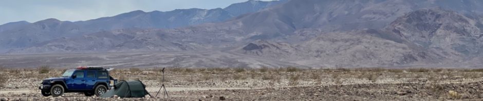
The tent is a four season black label tube tent from Hilleberg. It doesn’t offer much for views — I never imagined that I’d spend much time laying around in it — but the night before I left the vestibule rolled back and the inner tent unzipped. There were no bugs, rain, or wind to worry about. It wasn’t even particularly cold. As a result I have a morning view. I linger for a few minutes in my sleeping bag, taking it it.
It’s the sleeping bag that finally drives me from the tent. It’s an old mummy bag from my backpacking days. Now, here in this Jeep era, I find it annoyingly confining, and not at all nearly warm enough. The cold was pushing through in the pre-dawn light. It seems like I need to make an adjustment to the gear, although I’m not sure what I would replace it with.
The sun is shining off the mountains to the northwest when I emerge from the tent. It’s a peaceful scene, and it has its own harsh beauty. I have no real connection to the desert. It is utterly alien to the dense pine forests, sky blue waters, and brilliant white snowfields of my youth. But there is a barren beauty to this place. I might as well be on Mars, the landscape is that alien to my eyes, but still I’m relaxed and content to be there. It’s a nice place to be, although I don’t think I’d want stay overly long. But it is a reprieve from my normal life, and I welcome it for that.
A quick glance at the tent reveals what I suspected; I didn’t get it pitched tight enough. Even in the light wind, the outer rain fly is flapping against the inner tent. I resolve to do better tonight.
I pause to study the scene around me. The landscape is rock, devoid of life save a few scraggly, stubborn bushes. I kick at the ground and my boot just skids over the surface. Frowning, I take the shovel off my jeep and stab experimentally. The stones are tightly packed, and the steel simply scrapes along, refusing to dig. After a few minutes of bemused exploration in the surrounding rock field, I finally admit to what I suspected the night before. There won’t be any digging of cat holes here. For the first time I understand why the recent explosion in overlanding has given rise to a market for portable toilets. I don’t have one, but I think I could come to regret it if I’m not careful. Fortunately, I don’t have an actual need but I am mindful of the distance to the next restroom.

That said, I have nowhere to be and all day to get there. I enjoy the experience as I get to the business of making a rudimentary, if filling, breakfast. Normally my days are so loaded with todo lists that I know I’m behind schedule the minute I open my eyes. But this morning, the only thing I have to worry about is not burning the bacon. Its a luxurious feeling that leaves me in no kind of hurry at all.
The only sign of people are the small scattering of vehicles some distance up the road. It looks like there’s a tight grouping of camping spots there, or maybe a big spot with a group of people. It’s too far to see. After a while, a pickup truck slowly makes its way down the road and past my camp, its driver giving me a cheery wave. I’m just finishing up the breakfast dishes when another vehicle picks its way slowly down the road. It’s a van, and it slows to a halt next to my camp. The driver rolls down his window — a man of about my own age — and he says ‘hello’. I nod, and smile, and wander a bit closer to see what he wants. Not too close, though. I maintain my Covid distance. He points at my Ready Light, which I left set up the night before with the hopeful idea that the morning sun would charge it.
“Is that a solar panel?” he asks me.
I explain that it’s a solar-powered light, not that the morning overcast is doing it any favors. He smiles and agrees his own solar panels were next to useless this morning. We chat for a few moments and then, puzzled, I ask him if his van is a four wheel drive. It seems awfully low to the ground. “No,” he tells me with a rueful little smile, “just two wheel drive.” I express surprise that a two wheel drive van can make it up the road. He says he wouldn’t recommend it to anyone other than himself.
Amused, I tell him I get it, and I talk for a bit about exploring Northern Minnesota forest service roads in a Honda Civic. He laughs, agrees that it can be done, if you’re careful enough. “And willing to repair your suspension every year,” I add.
After a bit, he eases on down the road. I watch him pick his way along for a moment, shaking my head. Everyone has to ride their own ride. I didn’t ask, but I wonder if the crowded conditions in the park caught him as much by surprise as it did me. Was that what sent him up this road? Or was he looking for the solitude that I found almost by accident?
Later, I’ve got the camp completely torn down, except for my tent. I pay particular attention as I unscrew the lag screws that serve as tent stakes, and then fold the tent for transportation. I’m thinking about how to do this more efficiently, but also how to make it efficient to set it up again tonight. I don’t need to be fumbling with this thing twice a day. It want to be so good that I can set up and tear down blind folded.
Finally I’m on the road. It’s around 10 am and the high cloud cover has blow through, brightening the day. I didn’t bother to air down the night before, but I’m in 4-wheel high and I’ve got the sway bar disconnected. Brother Blue rolls along, not at all concerned by the rough, rocky ground under foot. For the most part this early section of the canyon road is reasonably flat with few ruts. Four wheel drive isn’t really necessary. Some ground clearance is important. Far more critical are reasonably rugged tires. The loose, sharp rocks in the road bed would tear street tires apart.
At the bottom of the road, just before West Side Road, I come to a particularly rutted section. I’m a little surprised that the park service didn’t smooth this out more, but then I wonder if it is left as a deliberate obstacle to keep passenger cars from leaving West Side. Brother Blue barely even notices the ruts, but I think back to my old Honda Civic. Would I have attempted this? I finally decide that I would have, but only if I was particularly anxious for a place to camp. I wonder how many Death Valley visitors have had to make that decision.
 West Side Road is wide, flat, and well groomed with only the slightest of washboards. If I go left, I’ll back track the way I came the night before. If I go right, it’ll be all new. I pull up Gaia GPS. It looks like there’s more canyons and various points of interest along the big, easy road. I decide to go right.
The speed limit along West Side is a mystery, so Brother Blue just loafs along at around 25 mph. There are many stops to get out, to walk into the desert a bit, to soak in this place. One such place is Bennett’s Long Camp, which is nothing more than a marker on the side of the road. The marker says a group of forty-niners were stranded there for a month and almost starved to death. They only survived because two of their members made a journey on foot to San Fernando for help.
Later, after this trip is done, I’ll discover that the Bennett camp is probably where Death Valley’s name came from. They all thought they were going to die. Upon rescue, as the group was lead out over the Panamint Mountains, one of them looked back and said “goodbye, Death Valley.” It explains the marker, at least, although the deeper historical significance of the place is not mentioned on it.
The road to Butte Valley also turns up along the way. I’m surprised, because for some reason I thought that was in the north part of the park. Somewhere up that way is Barker Ranch where Charles Manson was captured. There are also scattered cabins and mining camps to visit. The road is as wide open and easy as West Side, but it probably doesn’t stay that way. I’m tempted to follow it all the way to Miner’s Cabin, but I resist the urge. I’ve told no one that I’m going that way. True, I have the inReach, but there’s such as thing as pushing your luck too far. Butte Valley will have to wait for another trip.
West Side goes on and on and on, and the needs of my body are making me increasingly uncomfortable. Maybe I should have gone left instead of right. Really, there isn’t much of anything here. I see some scattered people who look like they’ve been truck camping, but otherwise there are no crowds, no traffic, certainly no restrooms. My mistake. In my discomfort, I vow to invest in a portable toilet as soon as I get home.
Finally, a cut over to pavement opens to the right. Maybe another mile and I’m at two lane blacktop. Left or right? I look at the map and decide that my best bet is once again right. This time I luck out. A mile, maybe two, and I round a curve to see a distinct rectangular structure silhouetted on a hill top. Sure enough, it’s a pit toilet. The location is the Ashford Mill Ruins, which is set up as a picnic spot. The ruins are utterly deserted, but the pit toilet is open for business. And, really, has anyone ever gone a road trip and not felt the sweet relief of locating a toilet stop just as it is needed the most? It’ll be a long time before I forget about Ashford Mill, and not just because it’s a historically interesting place.
Ashford Mill was a gold ore processing plant that began and ended in 1914. All that’s left today are some empty walls, a concrete slab, a few random bits of iron. As I wandered around looking it over, it occurs to me that Ashford Mill’s story could easily be the same as any of hundreds, perhaps thousands, of Silicon Valley start ups. It began and ended quickly, money was spent, virtually none was made. The only thing left in its wake was a scar on the land and some memories. The only difference between this place and Silicon Valley is that Silicon Valley is way better at recycling real estate.
Silicon Valley might be the last remaining gold rush town in North America, although what gets mined here is not gold. Ashford Mill explains it all. Get a vision, spend money, work like hell, and if it fails, fail hard. Never mind the wreckage left behind.
I wander back up the hill to the parking lot to discover two vehicles have joined me. Somehow I think their take on these ruins is nothing at all like mine.

From Ashford Mill, I turn north on Badwater Road. Truth be told, I’m a little confused as to what road I’m on. It seems like I should be on 190 heading back to Furnace Creek, but in reality I’m on Badwater. It’s not a substantial difference, I’ll end up at the same place either way, but it does show how tired I must have been the day before. I completely forgot that I’d turned off of 190 in my quest for a camp site. 190 ends somewhere far to the north east. There was never any chance that I could have come this far south and stayed on it.
The drive up Badwater is long. Traffic is spotty but present, with multiple RVs and slow moving minivans barely making the speed limit. Winding up the road, I’m struck by just how big this park is. At 5,000 square miles, it is larger than the two smallest US States (Rhode Island and Delaware). Puerto Rico is larger, but not by much. Distances are vast in the park, facilities are few and infrequent. The National Park Service makes it sound like flat tires are the most common cause of road break downs in the park. I’ve a hunch that running out of a gas is somewhere in the top five.
You don’t have to try very hard to find a whole bunch of empty in Death Valley, but if you want company all you have to do is go to one of the famous visitation sites in the park. I roll past Badwater Basin. It’s the lowest spot in North American (282 feet below sea level), but it is also world famous. The place is crawling with people. They’re wandering into the highway, so Brother Blue slips to a slow purr as we slip by. I came here multiple times in my Motorcycling Era, so it holds little interest for me. More, with Covid, I have no desire to share the attraction with hundreds of other people.
It is well past noon before Furnace Creek is in our rear view mirror, and we’re north bound on North Highway. This leads to Scotty’s Castle which is another world famous destination, but it’s currently closed for renovation. Nevertheless, there are things up north that I want to check out. The first is Mesquite Spring. I can’t tell from the map what’s there, other than a campground.
Turns out, that’s pretty much it. There’s a Ranger Station. But that end of the park is really just Mesquite Spring Campground and Scotty’s Castle. Ubehebe Crater is there too, and the race track if you’ve got vehicle enough to get there. But it seems like the primary attraction is the campground and Scotty’s Castle. And the castle is closed. Past these handful of attraction, that there’s just endless miles of dirt road.
All the pavement is making me grumpy. I pick it up, passing two or three slower moving vehicles. I want to get to the end of this road and figure out where I’m going to go from there.